Geo-archaeology and Haíɫzaqv oral history: Long-term human investment and resource use at EkTb-9, Triquet Island, N̓úláw̓itxˇv Tribal Area, Central Coast, British Columbia, Canada
 Keith Holmes
Winter Arctic Outflow Winds Cause Upper Ocean Cooling and Reoxygenation in a Temperate Canadian Fjord
J. M. Jackson , K. Holmes , J. M. Klymak , L. Bianucci , W. Evans , W. C. Floyd, C. G. Hannah4 , A. Hare , and D. Wan.
https://agupubs.onlinelibrary.wiley.com/doi/pdf/10.1029/2023GL104549
Arctic outflow winds bring cold air from the continent to the coastline through mountain passes. Using observational data and a 2-D model, we show that a February 2019 outflow event caused the upper 100 m in Bute Inlet, British Columbia (within the traditional territory of the Homalco Nation) to cool up to 1.9°C and gain up to 4.1 mLL−1 of oxygen. The cold, oxygenated water persisted for almost 1 year within the 1,023–1,023.5 kgm−3 isopycnal range (∼50–150 m). Atmospheric (from 1929 to 2022) and oceanographic (from 1951 to 2022) data showed a statistically significant relationship between continental air temperature at Tatlayoko Lake and temperature and oxygen in Bute Inlet. This local mechanism that counters some effects of climate change could create a biological refugium as surrounding waters warm and lose oxygen at a faster rate. The number of outflow events decreased from 1951 to 2018, and increased since.
Ancient Ecology: The Quadra Island Clam Gardens
3500 years of shellfish mariculture on the Northwest Coast of North America
Nicole F. Smith, Dana Lepofsky, Ginevra Toniello, Keith Holmes, Louie Wilson, Christina M. Neudorf, and Christine Roberts
https://journals.plos.org/plosone/article?id=10.1371/journal.pone.0211194
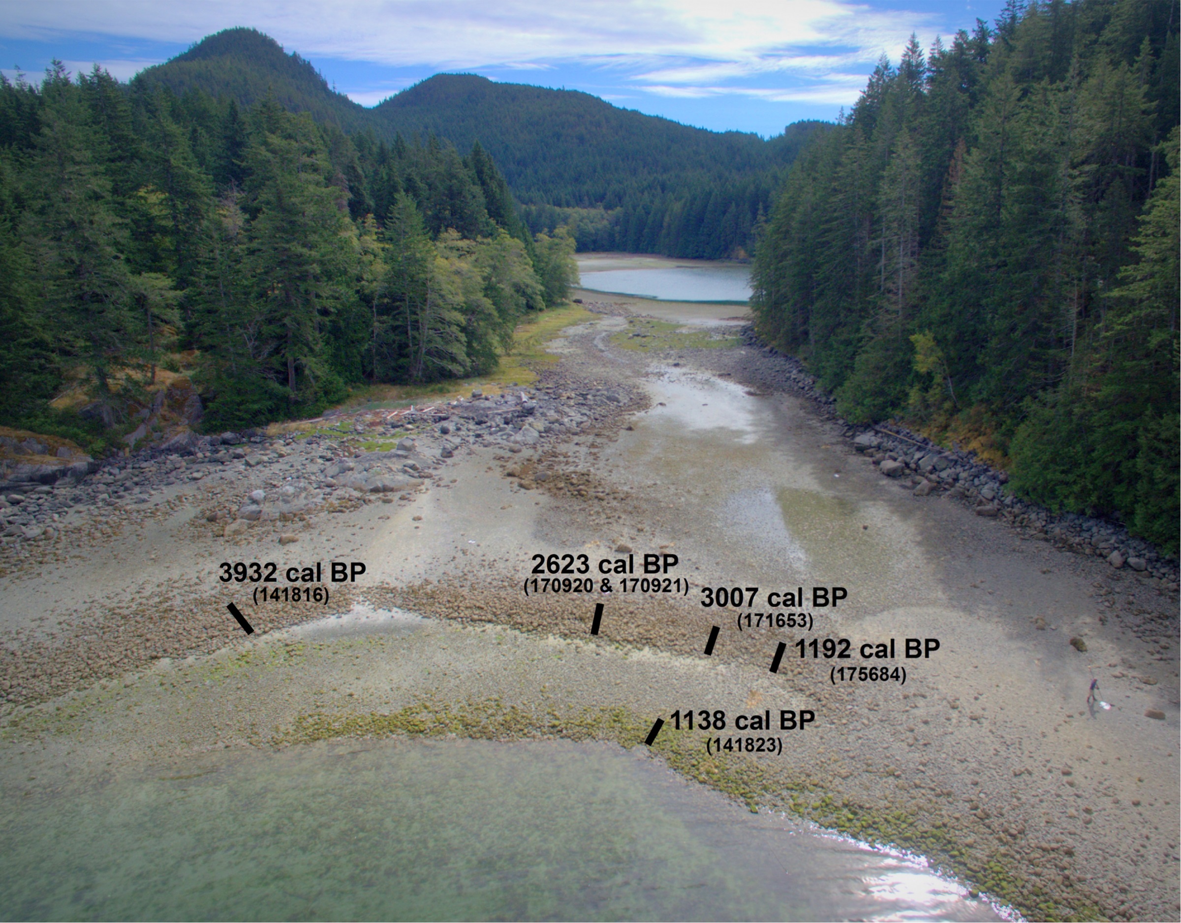
Ancient systems of mariculture were foundations of social-ecological systems of many coastal Indigenous Peoples. However, since such systems either do not leave tangible remains in the archaeological record, and/or are hard to date, we know little about their development and use. Clam gardens, traditional mariculture features located within the intertidal zone along the Northwest Coast of North America, are composed of a rock wall positioned at the low tide mark and a flattened terrace on the landward side of the wall. Because these features are largely composed of rock and sediment, and have complex formation histories, they can be difficult to age. On northern Quadra Island, British Columbia, we identify three variations in clam garden form, constructed in different geomorphological settings, each of which require different sampling approaches to obtain ages on construction and ongoing use. To age the clam gardens, we consider radiocarbon dating of invertebrates that inhabit beach deposits (both pre- and post-garden construction), and the relationship of the gardens and clam samples to the local sea level history and taphonomic processes. Within our study area, we find clam gardens have been in use for 3500 years, likely corresponding to other social and ecological changes of the time. These data allow us to formulate guidelines on samples most suitable to constrain the age of initial and on-going wall construction and use of clam gardens, which can be extrapolated to dating other ancient mariculture features in other regions. Such dating programs are the foundation for understanding the long-term development of traditional marine management practices and how they are situated in broader social-ecological systems.
Ancient Anthropogenic Clam Gardens of the Northwest Coast Expand Clam Habitat
Dana Lepofsky, Ginevra Toniello, Jacob Earnshaw, Christine Roberts, Louis Wilson, Kirsten Rowell, & Keith Holmes
https://link.springer.com/article/10.1007%2Fs10021-020-00515-6
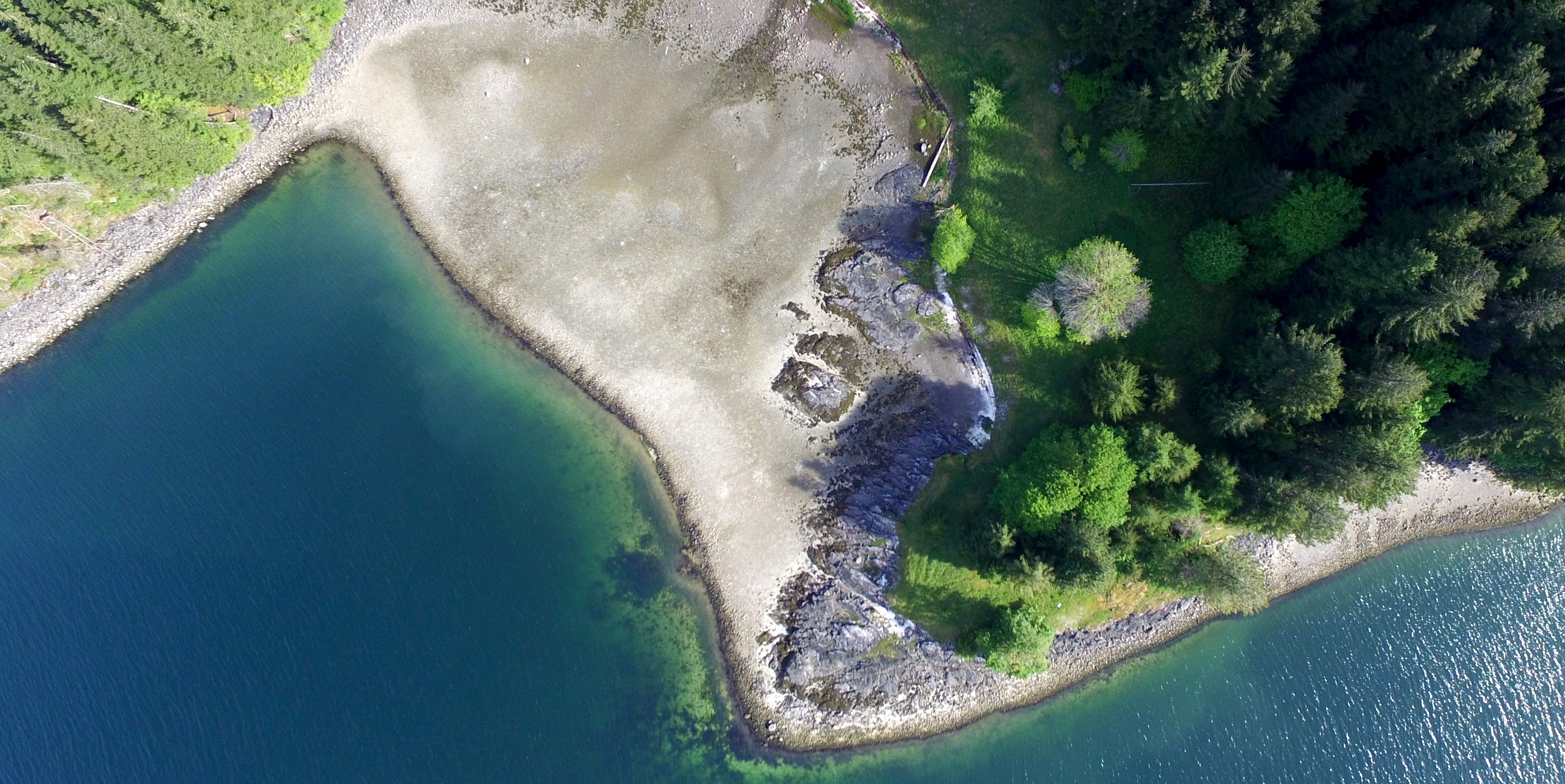
Clam gardens are ancient mariculture features developed by Indigenous Peoples of the Northwest Coast of North America that create shallow sloping intertidal shelves where clam productivity is enhanced. We quantify the area of clam habitat created by constructing rock-walled clam gardens terraces in northern Quadra Island, British Columbia, Canada. We combined modelling, high-resolution mapping, beach sampling, and a comprehensive survey of the shoreline to document the location and areal extent of clam habitat in clam gardens today. We divided our analysis into three classes of clam gardens, which differ in substrate and thus the amount of clam habitat created. We found that Indigenous People built clam garden walls on 35% of the shoreline and that about 112,979 m2 of flat beach terrace were created by clam garden construction. Collectively, the three classes of clam gardens increased clam habitat area between 26 and 36%. About 35% of the area of clam habitat in clam gardens was constructed de novo on bedrock shelves and rocky slopes where no clam habitat existed previously. Furthermore, about 12.0% of clam gardens are smaller than 30 m2, reflecting the effort put into creating enhanced food production wherever possible. Our analysis demonstrates that clam management in the form of clam gardens was extensive prior to colonization and that these features still have a significant impact on today’s intertidal ecosystems. Clam habitat expansion facilitated by clam garden construction encouraged a sustainable and abundant food source in the past and could do so again in today’s changing environmental conditions.
Sudden collapse of a mesopredator reveals its complementary role in mediating rocky reef regime shifts
https://royalsocietypublishing.org/doi/full/10.1098/rspb.2018.0553
While changes in the abundance of keystone predators can have cascading effects resulting in regime shifts, the role of mesopredators in these processes remains underexplored. We conducted annual surveys of rocky reef communities that varied in the recovery of a keystone predator (sea otter, Enhydra lutris) and the mass mortality of a mesopredator (sunflower sea star, Pycnopodia helianthoides) due to an infectious wasting disease. By fitting a population model to empirical data, we show that sea otters had the greatest impact on the mortality of large sea urchins, but that Pycnopodia decline corresponded to a 311% increase in medium urchins and a 30% decline in kelp densities. Our results reveal that predator complementarity in size-selective prey consumption strengthens top-down control on urchins, affecting the resilience of alternative reef states by reinforcing the resilience of kelp forests and eroding the resilience of urchin barrens. We reveal previously underappreciated species interactions within a ‘classic’ trophic cascade and regime shift, highlighting the critical role of middle-level predators in mediating rocky reef state transitions.
Using unmanned aerial vehicles (UAVs) to measure jellyfish aggregations
Jessica Schaub1, Brian P. V. Hunt, Evgeny A. Pakhomov, Keith Holmes, Yuhao Lu, Lucy Quayle
https://www.int-res.com/abstracts/meps/v591/p29-36/
MEPS 591:29-36 (2018) - DOI: https://doi.org/10.3354/meps12414
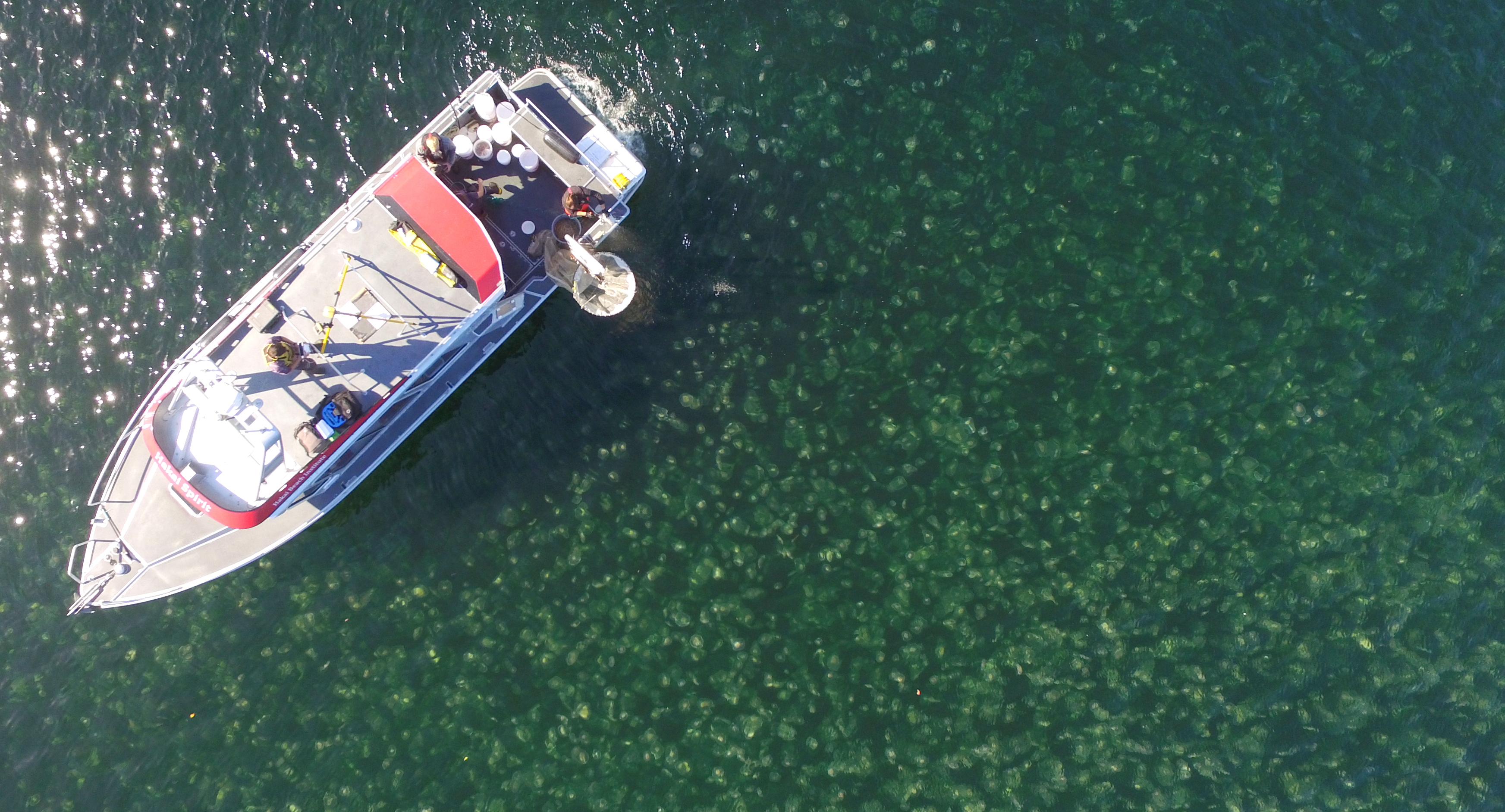
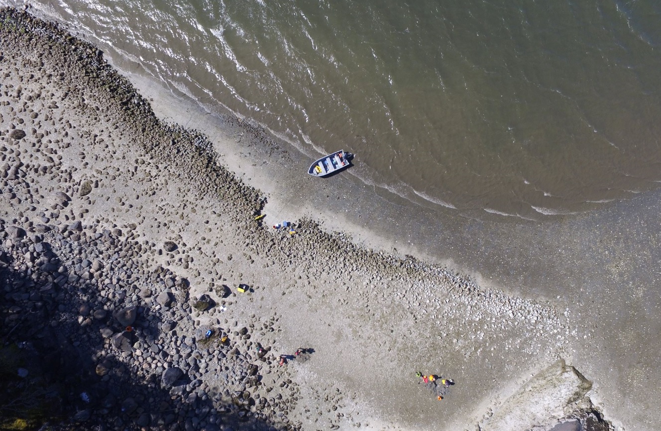
ABSTRACT: Unmanned aerial vehicles (UAVs, or drones) are becoming increasingly common as tools to perform high-resolution but broad-scale measurements of habitats and populations simultaneously. In this study, we tested the application of UAVs to aerial surveys of jellyfish and their suitability for measuring and monitoring aggregations. We paired net hauls with linear image transects taken by a UAV to measure 5 Aurelia spp. aggregations over the course of 1 d in Pruth Bay, British Columbia, Canada. Georeferenced image transects were processed to determine aggregation areal extent and estimate percent cover of jellyfish. The percent cover estimates and net haul density data were highly comparable for all aggregations. Using combined UAV-derived surface area estimates and net haul biomass estimates, we calculated that jellyfish aggregation size ranged from 65 to 117 t wet weight biomass. We discuss the potential for additional UAV-based measurements including jellyfish abundance and individual size. The study demonstrates the potential of UAVs as powerful tools for characterizing and researching jellyfish aggregations in situ.
Masters Publications
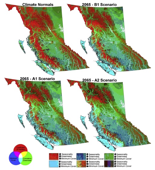
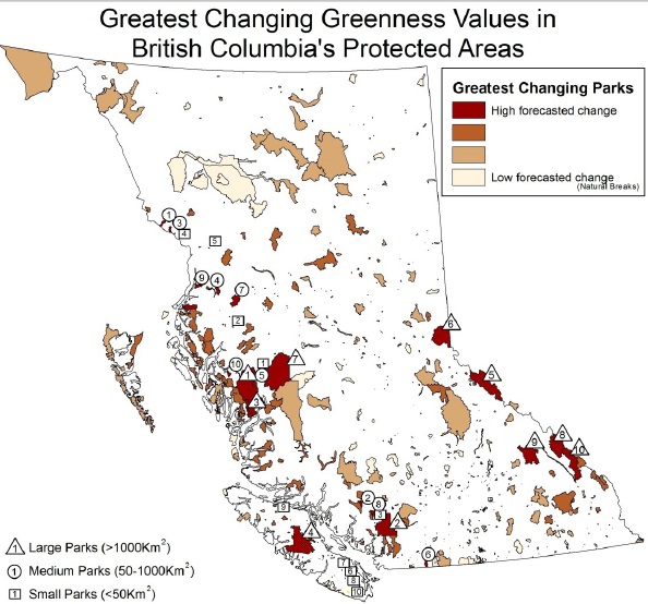
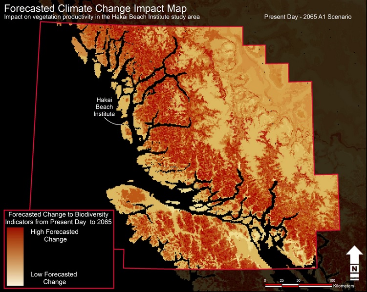
Climate Change Impact Map
Predicted impacts to ecosystems in British Columbia due to climate change:
Use the zoom in tools to take a close look at the forecasted change to biodiversity indicators in British Columbia. The red regions will experience the most change and the pale areas are more stable. This map used the change observed from the composite Dynamic Habitat Index from present day to 2065 using an average A1 (business as usual) scenario.
Hakai Beach Institute - Climate Change Impact on Central Coast Ecosystems