
Bio-Climate Research Abstract
Forecasting Change in Biodiversity across British Columbia due to Climate Change:
An Indirect Indicator Approach
Forecasting biodiversity in British Columbia is a useful strategy to implement differing scenarios towards understanding the impact of climate change upon species richness and diversity. In order to conduct forecasting, past relationships must be characterized to enable projection of future possible outcomes of climate change. A unique archival dataset sourced from the advanced very high resolution radiometer (AVHRR) satellite records broad indicators of biodiversity from 1987 to 2007 which enables the modeling of climate and biodiversity relationships. Indirect indicators of biodiversity are derived from the AVHRR data such as the dynamic habitat index (DHI) which partitions changes in plant productivity into measures of landscape seasonality, minimum growth, and total greenness of different habitat types along with a variety of climate variables. Regression analysis will be performed on 106 ecodistricts in British Columbia to understand the spatial-temporal trends between the DHI and climate. Auxiliary data sources will be required to explain DHI-climate relationships, with supplemental data relating mountain pine beetle infestation, forest fires, and irregular climatic events. Expected results will show a warmer and wetter environment which will lead to increased productivity, with plant productivity shifts northward and to higher elevations. Outcomes will also highlight regions that have experienced the greatest amount of vegetation response over the 20 year period. Modelling past and future trends to biodiversity due to climate change provides valuable spatial information to aid decision maker’s efforts to conserve species richness and diversity, guide policy making, and gain a better understanding of ecosystem response to climate change.
 Keith Holmes
Climate and Biodiversity in Canada's Boreal Forest
Spatial-Temporal Analysis of Biodiversity and Climate Change Relationships: A Spatial Statistical Approach.
GEOMED Conference Poster - October, 2011. Victoria B.C.
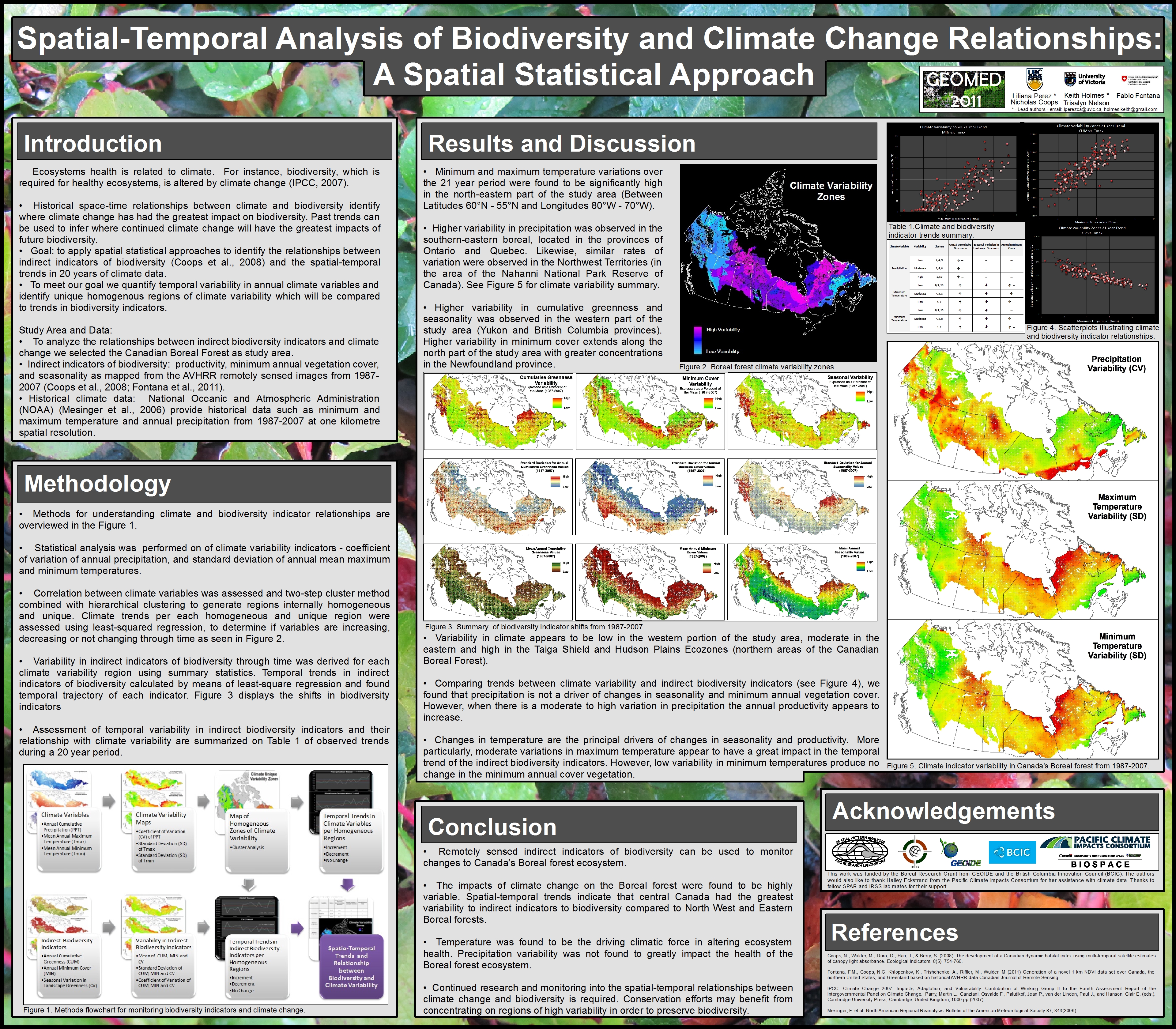
This poster looks at the use of high spatial resolution climate data and biodiversity indicators (based on the Dynamic Habitat Index) to understand relationships between climate variability and biodiverstiy in Canada's Boreal forest from 1987-2007. Created by Liliana Perez and Keith Holmes.
Climate Variability 1987-2007
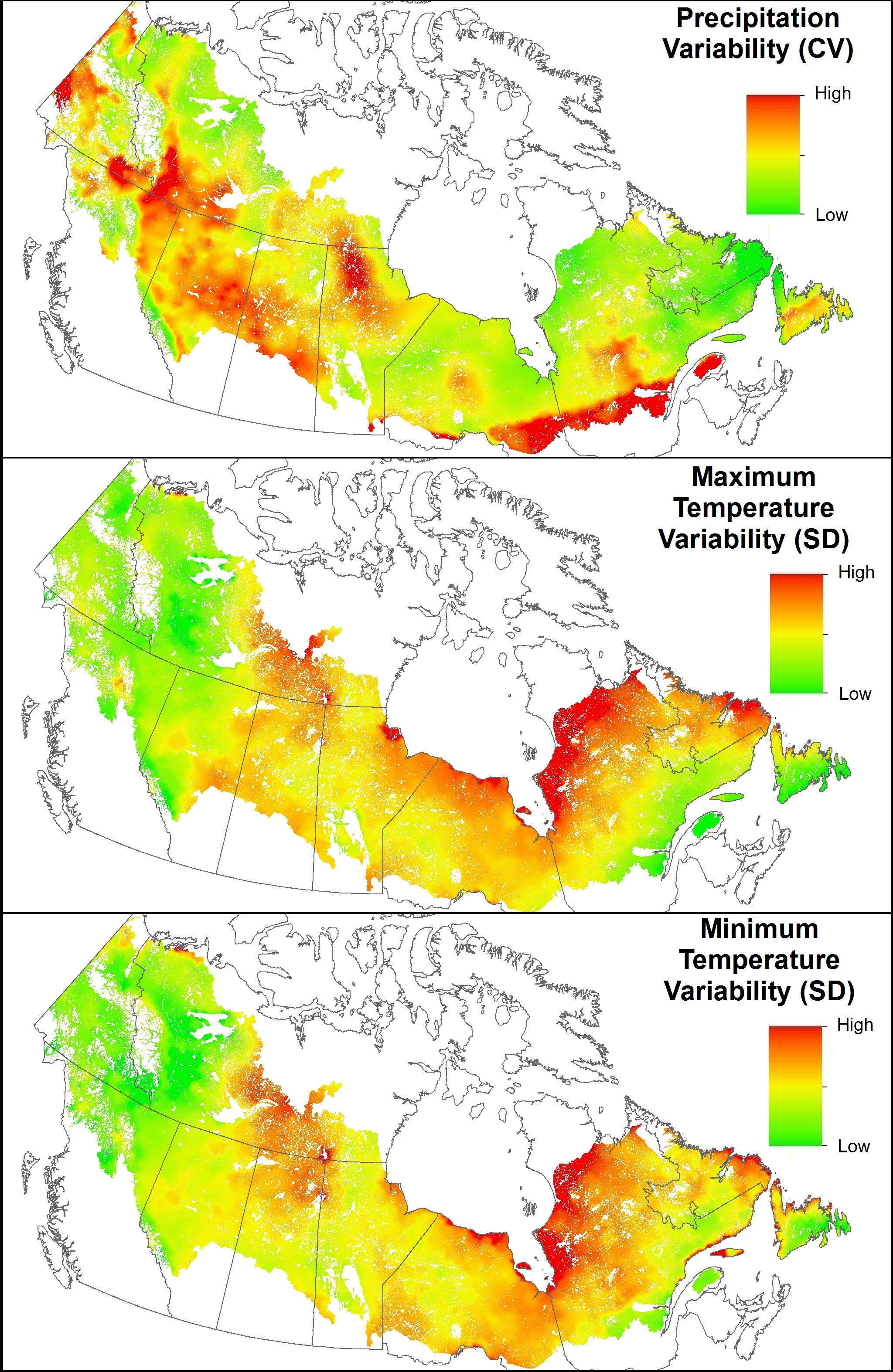
Climate variability indicators in the Boreal forest of Canada. 1987-2007. Map created by Liliana Perez.
Canada's Boreal Forest Climate Variability
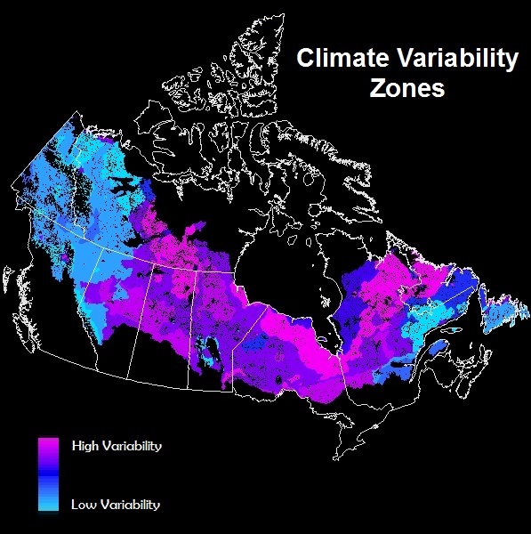
Climate variability - measured from 1987-2007. Using maximum temperature, minimum temperature, and precipitation indicators.
Map developed by Liliana Perez.